Last week, amidst some interesting weather, blowing snow, and what looked like (to the untrained observer) real snow falling, I reported that we were actually getting snow at the South Pole. As it turns out, the precipitation we received here was actually “snow grains”, not real snow. To clear up a bit of the confusion, and fill my in on general weather phenomenon here, I asked our Meteorologist Phillip Marzette a few questions.
Over the last few days here at the south pole, I’ve noticed some snow-like precipitation. I hear it’s exceedingly rare to get actual snow here. Was that snow we got, or something else? How often does it actually snow here? What’s the main form of precipitation?
As far as precipitation at South Pole, they come in three forms; ice crystals, snow grains and snow. Ice crystals appear about 90% of the time and are the product of water vapor after it encounters very cold and dry air poleward. Snow is made up of six-sided dendrite branch crystals. These are rare at South Pole and occur with warmer temperatures. Snow grains (8-9% occurrence), like snow, occur in warmer temperatures but they are more opaque, graupel-like in structure. Snow grains are what you saw out there, Jeffrey and there hasn’t been any “snow” recorded so far this season.
So, if we’re in a desert here and there’s such low amounts of precipitation, why is the ground covered with snow? Why isn’t it just slick ice on the surface?
The snow on the ground has mainly to do with the continent drifting towards the polar regions over millions of years. During that time, accumulations here have topped out at 2 miles while places further into the continent are at 3 miles. The ANDRILL project here on the continent can tell you more about that than I can. Over time, the snow hasn’t had a chance to melt and refreeze into ice that we are accustomed to, so the ground is still soft to walk on at South Pole.

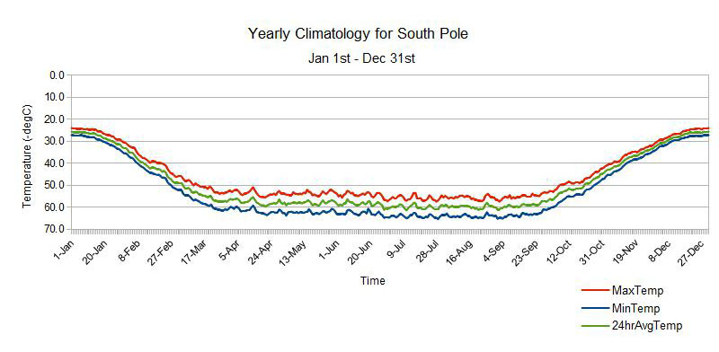
In addition to the light precipitation we’ve had lately, there’s also been a thick cloud cover, and it’s also been very warm – maybe around -10F. Do these have anything to do with each other?
As far as clouds bringing us warmer weather, that’s a two part answer. The first part being that clouds in general do a good job in trapping in longwave radiation, thereby keeping our temperatures up. The second part is a tad more complicated, but I’ll try to explain. At South Pole, the coldest air settles at the surface and the air is warmer above us. This condition is called an inversion. When cold air meets warmer air, conditions become calmer, while when warm air meets cold air, that’s when we get clouds. When we have low pressure air moves upward from the surface, while when we have high pressure air moves downward to the surface. During low pressure at Pole, the colder air at the surface meets the “warmer” air aloft and conditions are pretty good. During high pressure events, the warmer air goes down to the cold air and we get our clouds, precipitation and otherwise bad weather.
So far during my time here on the ice (Since November 13th), I’ve seen ice crystals drifting in the air, sundogs, thick haze, weird wave-like clouds, and driving winds. What other special weather phenomenon are you looking forward to seeing during the summer season? Anything really special we haven’t seen yet?
As far as anything else that pops up, we do have some Kelvin-Helmholtz clouds (the clouds that look like ocean waves, due to different layers of stability in the atmosphere) that show up from time to time. Other than that, it just learning more and more about what weather events occur normally at South Pole that I would not see anywhere else around the world.

Thanks Phil!


